 | |
 | |
 | |
 | |
 | |
 | |
 | |
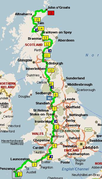
Ride Route
The following map gives a broad idea of the route we will be taking, generally we took guidance from the Lonely Planet - Cycling Britain Guide (ISBN 1864500379) along with a considerable amount of Internet research, there are plenty of equally self indulgent sites out there!
|
|
We have booked all our accommodation in advance - leaving us no scope for slippage or major disasters. Maybe that is tempting fate, but we have a limited amount of time off work and don't want to be in a position of not being able to find accommodation.
Day one is taken up with train travel to Penzance from our homes hence the miniscule cycling distance. The reason for some of the distance irregularity is to account for some pretty nasty climbs like the ascent to Scotland's ski fields on day 12.
We are staying in a combination of Youth Hostels and B&Bs throughout the fortnight. In this way we have kept accommodation costs to a minimum and if anywhere is grotty we'll only be there for a night so who cares!
We are using a 4 miles to 1 inch road atlas as a map from which we will tear out the 26 pages we need (13 pages of A4 each hardly constitues a massive weight burden). We have marked out the route in detail onto these pages in highlighter and have a handlebar mounted map carrier so the route will be under our noses all day. This has worked very well for us on training rides, with the latest 93 mile ride through Wales yielding only one small navigation error.